
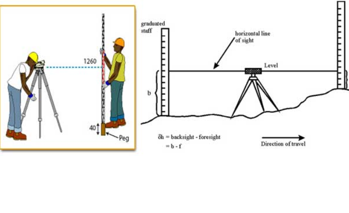
The principle of leveling is based on establishing a horizontal line of sight from a leveling instrument and determining the vertical distances of points above or below this line. This is accomplished by using a leveling instrument that provides a stable horizontal line, and a graduated leveling staff held at various points to measure the height difference with respect to this line of sight.
Readings are taken on the leveling staff placed at different ground points. The difference between these staff readings at different locations gives the difference in elevation between those points.
The working equation often used is that the difference in staff readings corresponds to the change in elevation between two points, allowing the reduced levels of unknown points to be computed relative to a known reference point or datum.
- Obtaining a horizontal line of sight.
- Measuring vertical distances of points above or below this line.
- Calculating elevation differences from these measurements.
Important Considerations
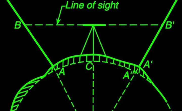
Earth’s Curvature: Surveyors usually make sure that the distances between the instrument and both staff locations are equal in order to lessen the effects of the Earth’s curvature. Curvature-related errors, which will be covered in more detail later, can be eliminated with this practice.
Instrument Setup: Accurate measurements depend on the instrument being properly leveled.
Staff Positioning: For accurate readings, the leveling staff must be held precisely vertical at each location.
Numerous setups: To maintain accuracy over longer distances or severe elevation changes, numerous instrument setups could be required.
Surveyors can precisely determine elevation variations across a variety of terrains and distances by comprehending and putting this idea into practice. This allows for accurate topographic mapping and engineering design.
Technical Terms Used in Leveling
- Level Surface
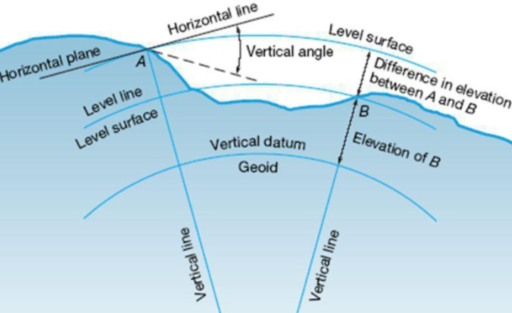
A surface that is parallel to the average curved surface of the Earth is called a level surface. Every point on this surface is equally distant from the center of the Earth. It is always perpendicular to the plumb line at any location. An example of this is the still surface of water in a lake. - Level Line
A level line is a line that lies on a level surface, meaning every point on this line is at the same distance from the center of the Earth. The edge or cross-section of calm water in a lake is an example of a level line. - Horizontal Surface
A surface that touches the level surface at one specific point(tangential) is known as a horizontal surface. It is perpendicular to the plumb line at the point of contact. - Horizontal Line
A horizontal line is a straight line that lies on a horizontal surface. It touches the level line at a single point and is tangential to it. - Vertical Line
A vertical line is a line that is perpendicular to a level line. The plumb line, which points straight toward the center of the Earth, is an example of a vertical line. - Vertical Plane
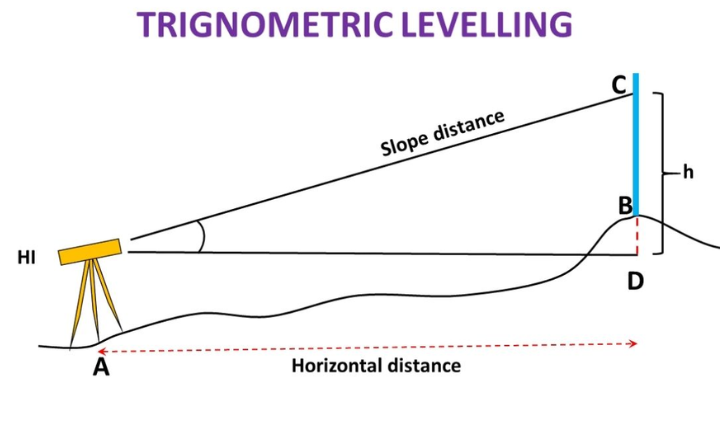
A vertical plane is a flat surface that contains a vertical line. - Vertical Angle
The vertical angle is the angle formed between a sloping (inclined) line and a horizontal line within a vertical plane. - Datum Surface
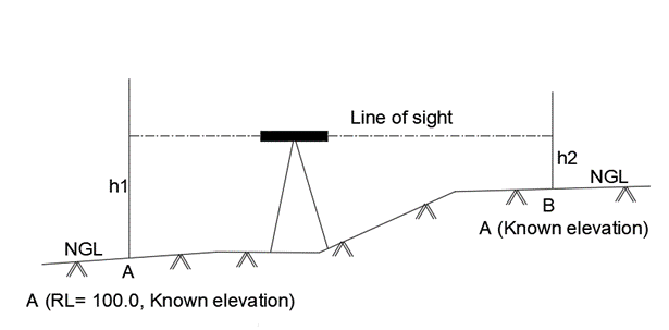
A datum surface is an imaginary level surface from which the heights or depths of points are measured. It serves as a reference level for all measurements.
- Mean Sea Level (MSL)
The Mean Sea Level is calculated by averaging the water level at a location over a 19-year period. This serves as the base reference for determining the elevations of different points in a region. In India, the Survey of India uses Mumbai’s sea level as the standard for this purpose. - Reduced Level (RL)
The Reduced Level is the height (above) or depth (below) a specified datum or reference point. It is also referred to as the elevation of a point. If a point is below the datum, it is assigned a negative elevation. - Line of Sight
The line of sight refers to the path along which light travels through the optical center of the instrument’s objective lens, passing through the eyepiece to the observer’s eye. - Line of Collimation
The line of collimation is the line that extends through the optical center of the instrument’s objective lens and intersects the crosshairs, continuing onward. This line is used for precise measurements. - Plane of Collimation
The plane of collimation is the horizontal plane in which a properly adjusted leveling instrument rotates about its vertical axis. - Optical Center of a Lens
The optical center is a point within a lens where light rays pass through without bending or being displaced laterally. It is positioned so that its distances from the lens’ curved surfaces are proportional to their radii. - Axis of the Telescope
The axis of the telescope is the line that connects the optical center of the objective lens and the center of the eyepiece. - Benchmark (BM)
A benchmark is a permanent and stable reference point with a known elevation above the chosen datum. It is used as a base point for leveling operations.
- Back Sight (BS): The first staff reading taken after setting up and leveling the instrument, usually on a point with a known reduced level (RL) like a benchmark.
- Fore Sight (FS): The last staff reading taken before moving the instrument, usually at a point where the RL is unknown and needs to be determined.
- Intermediate Sight: Readings taken on points between back sight and fore sight for which RLs are calculated.
- Datum Surface: A reference plane from which elevations are measured, often mean sea level.
- Reduced Level (RL): The height of a point relative to the datum.
- Leveling Instrument: The device (e.g., dumpy level, auto level, laser level) that provides a horizontal line of sight.
- Leveling Staff (Leveling Rod): A graduated rod held on the point to measure vertical distance from the horizontal line of sight.
- Height of Instrument (HI): The height of the instrument’s line of sight above the datum, calculated from the back sight.
- Line of Collimation: The horizontal line of sight through the leveling instrument’s telescope.
- Rise and Fall: Methods used for recording levels, where rise means an increase in height and fall means a decrease relative to the previous point.
Conclusion: Principle of Leveling
The principle of leveling is based on determining the vertical distance between points using a horizontal line of sight.
It ensures accurate measurement of elevation differences in the field, helping engineers and surveyors establish true ground levels for construction, roadworks, irrigation, and mapping projects. By applying careful observation, proper instrument setup, and error-checking procedures, leveling provides reliable and precise height information essential for safe and successful project planning and execution.