
The Types of Level used in Surveying are leveling instruments used in engineering surveying to measure height differences accurately on construction sites and land surveys. Leveling is the process of determining the relative heights or elevations of points on the Earth’s surface, whether on the ground or below it. This method is a critical part of surveying, https://primebuildengineering.it.com/types-of-tapes-in-surveying/, focusing on vertical measurements rather than horizontal ones. It plays a vital role in the planning and execution of various engineering projects, including railways, highways, canals, dams, and water supply systems. Accurate leveling is essential because the success of these projects depends on having precise elevation data for design and construction.
When engineers undertake a project, they need detailed information about the differences in elevation along the proposed routes or alignments. This data allows them to plan the layout, drainage, and structural features accurately. Leveling provides the framework of height measurements across the entire area involved in the project, ensuring smooth execution and minimizing errors.
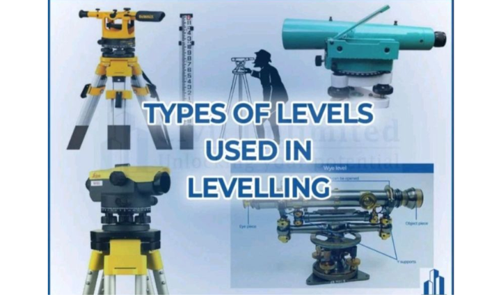
Types of Levels
The instrument used to carry out leveling is called a level. In surveying, the term “Types of Levels” refers to the different kinds of instruments used to measure height differences, establish level lines, and assist in vertical positioning for land and infrastructure projects. Each type of level serves specific functions, offers unique features, and is suited for particular conditions and accuracy requirements in civil engineering and surveying tasks.
The Dumpy Level
A fixed telescope level is renowned for its simplicity and stability. It is often used in routine construction and civil engineering projects, providing accurate and reliable measurements for short to medium distances. Its fixed design means it does not allow for tilting or automatic corrections, making it straightforward but less versatile in complex terrain.

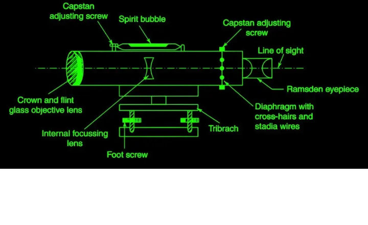
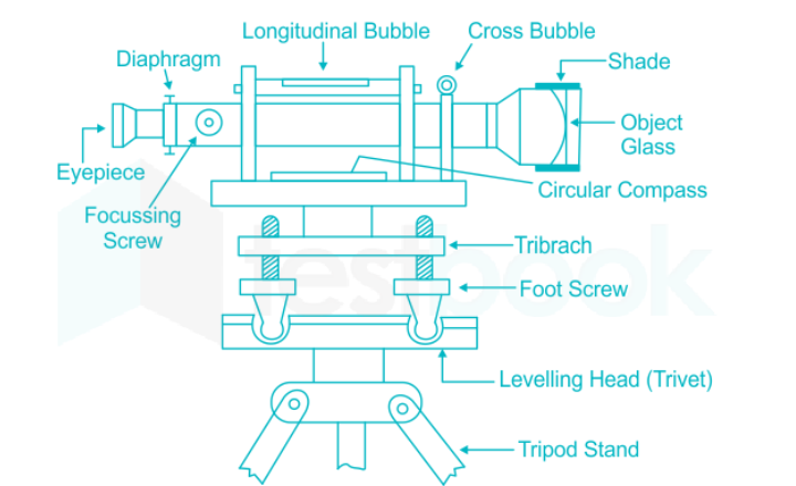
- The Dumpy Level, originally designed by Gravatt, is one of the most commonly used instruments in leveling operations. Its defining feature is the telescope, which is rigidly fixed to its support. This means the telescope cannot rotate about its longitudinal axis, nor can it be removed from its base. This fixed structure ensures stability and precision, making it ideal for taking several observations from a single setup.
- The name “dumpy” comes from the instrument’s relatively short and thick appearance compared to other leveling instruments, such as the Wye Level. The leveling head of the dumpy level typically consists of two parallel plates, held together by either three or four foot screws. The upper plate, known as the tribrach, is connected to the telescope, while the lower plate, or trivet, is mounted on the tripod, providing a stable base for the instrument.
Key Advantages of the Dumpy Level
- Simple Construction: The dumpy level has few moving parts, which makes it easy to use and maintain.
- Long-lasting Adjustments: Once the instrument is adjusted, these settings remain stable over a long period, reducing the need for frequent recalibration.
- Reliable for Multiple Observations: Its fixed design is particularly beneficial when several measurements need to be taken from the same location, as the instrument maintains its accuracy throughout the process.
Key disadvantages of the dumpy level
- Requires a clear line of sight; obstructions like trees or structures can affect accuracy.
- Sensitive to atmospheric conditions such as fog or heat waves that distort sightlines.
- Manual reading of staff can cause human errors like parallax and misinterpretation.
- Needs a stable, level setup; instability or improper leveling leads to measurement errors.
- Not suitable for high-precision surveys due to inherent accuracy limitations.
- Time-consuming setup and reading process, making it less efficient for rapid data collection.
- Lacks digital features and data storage capabilities, limiting efficiency in modern workflows.
- Requires skill for accurate measurements, which may pose difficulty for some engineers.
- It cannot measure horizontal angles accurately and is less flexible than modern levels, such as laser levels.
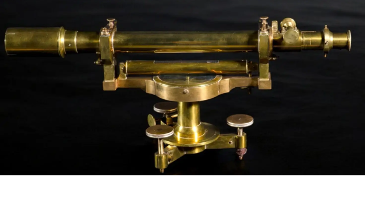
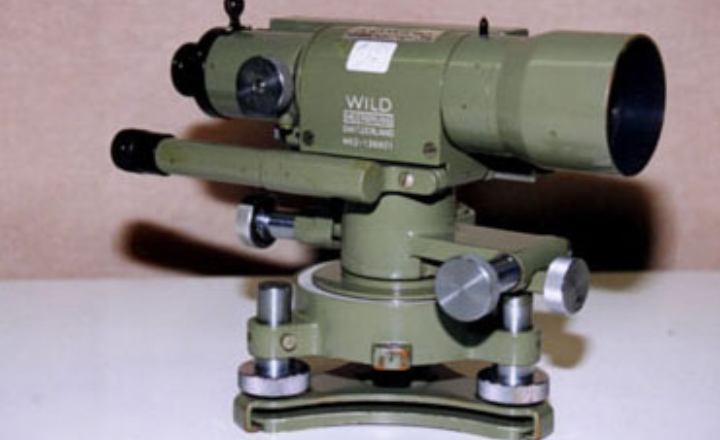
The Wye Level
The Wye Level, a lesser-known but essential instrument in the realm of surveying, boasts unique features that distinguish it from other types of levels. This dual-telescope setup allows surveyors to achieve remarkably accurate elevation readings, even in challenging terrain.
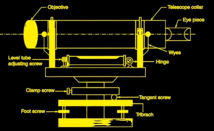
- The Wye Level (or Y-Level) is another commonly used levelling instrument, similar to the dumpy level but with a key difference: the telescope in the Wye Level is supported by two Y-shaped uprights. These supports allow the telescope to be easily removed and rotated around its longitudinal axis. Unlike the dumpy level, where the telescope is rigidly fixed, the wye level’s telescope can be detached by releasing two clamping collars on top of the Y-supports.
- This design offers the advantage of allowing adjustments to be tested quickly and easily. Since the telescope is not permanently fixed, it can be rotated, removed, or turned end-to-end for rapid checks. However, the wye level has more movable and exposed parts, which can lead to frictional wear over time. This makes it less durable compared to the dumpy level.
Key Features of the Wye Level
- Telescope in Y-Supports: The telescope is held in Y-shaped supports, which can be loosened or tightened to rotate or remove the telescope as needed.
- Rapid Adjustment Checks: The ability to quickly test adjustments is a significant advantage, making it useful for projects requiring frequent recalibration.
- More Movable Parts: While it offers flexibility, the wye level’s loose parts are prone to wear, meaning adjustments must be checked more frequently than with the dumpy level.
Advantages of the Wye Level
- Quick Testing of Adjustments: The flexible design allows for rapid checking and testing of settings, saving time when precision is essential.
- Rotation of the Telescope: The telescope can be rotated and removed, making it easier to conduct various checks without disturbing the overall setup.
Disadvantages of the Wye Level
- More movable parts lead to frictional wear over time.
- Less durable compared to the Dumpy Level.
- Requires frequent maintenance and inspection.
- A telescope can become misaligned if not handled carefully.
- Increased mechanical complexity can introduce measurement errors.
Frictional Wear: Due to the presence of many movable parts, the wye level is more prone to wear and tear, requiring frequent inspection and maintenance.
The Reversible Level
The reversible level is a remarkable tool in the realm of surveying, primarily known for its adaptability and efficiency. This functionality is particularly beneficial in situations where space or terrain makes conventional methods challenging, allowing for seamless transitions between back-sighting and foresighting.

- The Reversible Level combines the key features of both the dumpy and wye levels, allowing users to benefit from the strengths of each. The design includes a telescope similar to that of a wye level, supported by two rigid sockets. The telescope can be inserted into these sockets from either end and fastened securely with screws, giving it the ability to be reversed. When the telescope is fastened, the reversible level functions like a dumpy level, offering stability for precise levelling tasks.
- This ability to reverse the telescope provides an advantage in eliminating collimation error, which is the misalignment of the line of sight. By taking readings with the telescope reversed (often referred to as “bubble left” and “bubble right” readings), any small errors in alignment can be detected and corrected.
- Additionally, the reversible level allows for easier permanent adjustments compared to other levelling instruments. It offers both the flexibility of the wye level and the stability of the dumpy level.
Key Features of the Reversible Level
- The telescope, supported by two rigid sockets, can be reversed end-to-end.
- Reversible Telescope: The telescope can be removed and reinserted in the opposite direction, helping to check for errors in alignment and making it easier to adjust the instrument.
- Combination of Features: It combines the rigid setup of the dumpy level with the flexible testing capabilities of the wye level.
- Collimation Error Elimination: By allowing the telescope to be reversed, collimation errors can be identified and minimised, improving accuracy
- Easy Permanent Adjustments: Adjustments can be made more easily compared to other levels, making it a versatile choice for engineers.
- Allows error checking by “bubble left” and “bubble right” readings.
Advantages of the Reversible Level
- High accuracy: By reversing the telescope and taking readings in both positions, collimation errors are detected and eliminated.
- Error detection and correction: The reversing feature allows for quick identification and correction of alignment errors, ensuring reliable measurements.
- Combines stability and flexibility: It offers the stability of a dumpy level with the ability to verify and improve accuracy like a Wye level.
- Easy to check adjustments: The instrument’s design allows for simple verification of the adjustment settings without complex procedures.
- Reliable for precise surveys: Suitable for high-precision levelling tasks where accuracy is critical.
- Time-efficient: Reduces the need for repeated setups since error detection is built into the measurement process.
Disadvantages of the Reversible Level
- Complex mechanism: The reversible feature adds complexity, making maintenance and repairs more challenging.
- Higher cost: Due to its advanced design, it is generally more expensive than simpler level instruments.
- Requires careful handling: Proper handling and precise adjustment are necessary to ensure accuracy when reversing the telescope.
- Time-consuming setup: Reversing the telescope and taking multiple readings can take more time compared to simpler levels.
- Sensitivity to environmental factors: Like other optical instruments, it can be affected by atmospheric conditions such as wind and heat shimmer, which impact accuracy.
The Tilting Level
The Tilting Level is a specialized leveling instrument used in surveying that allows the telescope to be tilted slightly in a vertical plane for fine adjustments. It is a modified form of the Dumpy Level designed to enhance efficiency and precision without requiring perfect initial levelling.
Key Features of the Tilting Level
- Tilting Screw: The telescope can be tilted within a few degrees to accurately centre the bubble before each reading.
- Quick Levelling: The instrument requires only rough leveling, as the tilting screw allows for fine adjustments to the line of sight.
- Circular Bubble: A circular bubble is used to approximately level the instrument with the help of foot screws. The main bubble tube is then centred using the tilting screw.
Advantages of the Tilting Level
- Precise Adjustment: The tilting screw allows for exact centring of the bubble, improving the accuracy of each reading.
- Time-Saving: The need for only rough leveling reduces setup time, as the final adjustments are made using the tilting screw.
- Efficiency: Ideal for situations where only a few observations need to be taken from a single setup, such as in fly leveling.
The Tilting Level is especially useful for high-precision work, providing flexibility and efficiency through its tilting mechanism, while allowing for quick and accurate adjustments.
Disadvantages of the Tilting Level
- Requires careful centring of the bubble before each reading, which can be time-consuming.
- Less convenient than automatic levels, as it needs manual fine adjustments each time.
- Slightly more complex operation compared to the Dumpy Level due to the tilting mechanism.
- Not suitable for rapid surveying tasks or large-scale projects requiring multiple observations from one setup.
- Sensitive to environmental factors like wind or vibrations, which can affect the stability of the instrument.
Automatic or Self-Levelling Level
The Automatic Level, also known as the Self-Levelling Level, simplifies the levelling process by utilising a stabiliser or compensator that automatically adjusts the line of sight to be horizontal. While its design is similar to the dumpy level, with the telescope fixed to the tribrach, it incorporates a compensator mechanism to provide more efficient and accurate levelling.
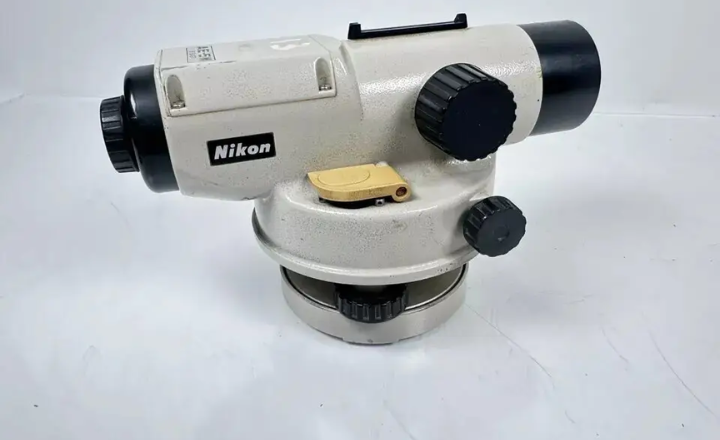
Key Features of the Automatic Level
- Compensator Mechanism: The compensator is a prismatic device suspended on fine non-magnetic wires within the telescope. This system automatically adjusts the line of sight by responding to gravity, ensuring it remains horizontal even if the instrument is not perfectly level.
- Circular Spirit Bubble: A circular spirit bubble is used for rough leveling. The instrument needs to be levelled within 15–30 minutes of arc for the compensator to function properly. This is typically done using three-foot screws and a small circular level (often called a “pond bubble”).
- Gravity-Based Operation: The compensator uses the force of gravity to stabilise the line of sight. As the instrument is roughly levelled, the compensator shifts the optical system, bringing the horizontal cross-hair to the correct alignment.
Advantages of the Automatic Level:
- Speed and Efficiency: The automatic compensator eliminates the need for precise manual leveling with a bubble, making it faster to use.
- Error Reduction: There is no risk of errors due to improper bubble adjustment, as the compensator automatically maintains the horizontal line of sight.
- Ease of Use: The instrument provides an erect image, making it user-friendly and straightforward to operate.
Limitations:
- Sensitivity to Wind and Vibrations: The compensator mechanism can be affected by strong winds or vibrations, which may interfere with its proper functioning.
The automatic level is highly efficient for large-scale levelling tasks and ensures accurate results without requiring meticulous manual adjustments. However, it is less suited for use in environments with significant wind or vibration, where its accuracy might be compromised.
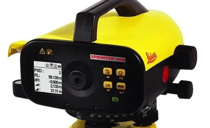
Digital Level
A Digital Level is an advanced surveying instrument that combines traditional optical levelling with modern digital technology to measure height differences with high accuracy and efficiency. The Digital Level represents a modern advancement in levelling technology, combining traditional optical techniques with electronic image processing to enhance precision and reduce human error. It operates in much the same way as a conventional optical level, but with the added capability of electronically measuring and recording observations.
Key Features of the Digital Level:
- Electronic Image Processing: The digital level reads from a specially designed bar-coded staff using electronic image processing. A detector diode array captures the signal pattern from the staff’s binary bar code, and a built-in correlation procedure translates this into the vertical staff reading and the horizontal distance from the instrument to the staff.
- Automatic Recording: Once the reading is obtained, the digital level stores the data automatically on its recording module. This eliminates potential errors associated with manual staff reading, data recording, and calculations.
- Ease of Use: The digital level is set up in the same way as a traditional level. After attaching it to a tripod and leveling it using the foot screws and circular bubble, the operator sights the bar-coded staff, adjusts the focus, and presses a measuring key. Within 4 seconds, the instrument displays the staff reading on the screen.
- Bar-Coded Staff: The staff used with digital levels has a binary bar code on one side and conventional graduations on the other. It is typically made from synthetic materials strengthened with glass fibers. The bar code comprises 2000 elements, with each element measuring 2 mm in width, allowing for precise electronic measurements.
- Display and Range: The digital display provides staff readings with selectable precision (either 1 mm or 0.1 mm). In addition, it can display the horizontal distance to the staff with a precision of 10 mm. The range of the digital level, under ideal conditions, is up to 100 meters, though performance may diminish under poor lighting.
- Power Supply: The digital level is powered by a small internal battery capable of running for a full day of levelling work before needing recharging.
Advantages of the Digital Level:
- Error Reduction: By automating the measurement process, the digital level removes common sources of error, such as misreading the staff and recording incorrect values in the fieldbook.
- Efficiency: With its automated readings and data storage, the digital level speeds up the levelling process, potentially reducing fieldwork time by up to 50%.
- Accuracy: The digital level offers consistent precision and reliability, reducing the chances of calculation errors through built-in programs for height computation and other tasks.
- Fatigue-Free Operation: Since the staff reading is taken electronically, the observer does not have to visually interpret the staff, reducing strain and fatigue.
- Online Data Transfer: The data collected can be transferred to a computer for further processing and analysis, making it easier to generate longitudinal and cross-sections in a short time.
- Dual Functionality: In situations where digital measurement is not feasible, the digital level can be used as a conventional level, providing versatility in the field.
Limitations and Considerations:
- External Factors: The performance of the digital level can be affected by environmental conditions such as wind, traffic vibrations, heat shimmer, and insufficient lighting, which may impact the compensator or the reading accuracy.
- Power Dependency: As the instrument relies on a battery, it is important to ensure it is charged for the duration of fieldwork.
Overall, the Digital Level offers significant advantages in terms of speed, accuracy, and error reduction, making it an excellent choice for modern surveying tasks. Its ability to store and transfer data electronically further enhances productivity and accuracy in levelling operations.
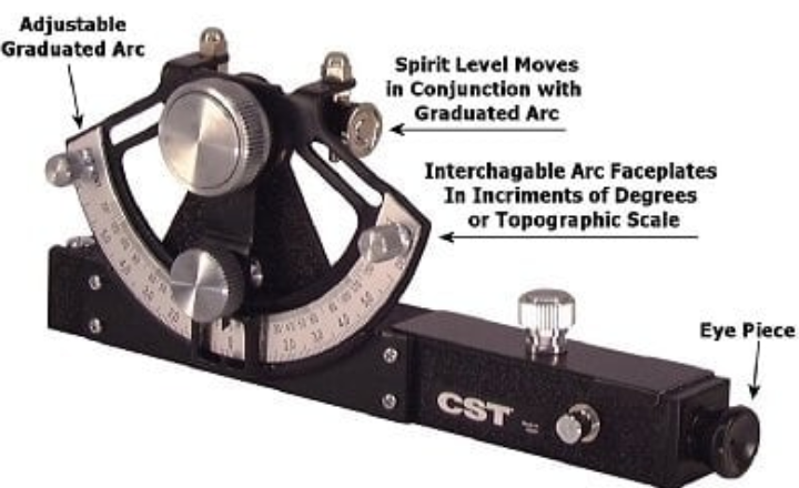
Hand Level
A Hand Level, also known as a Sight Level, is a simple, portable surveying instrument used for rough leveling and quick elevation estimations. It is essentially a spirit level combined with a small telescope.

Key Features of Hand Level:
- Consists of a telescope with crosshairs and a spirit level (bubble vial).
- Used mainly for rough leveling, not for high-precision work.
- Portable and easy to use, making it ideal for quick surveys and preliminary leveling.
- Suitable for applications like bricklaying, fencing, landscaping, and small construction projects.
- The operator holds it at eye level and adjusts until the bubble is centered to find the level line of sight.
- Enables rough estimation of height differences by reading a leveling staff through the telescope.
- Saves setup time compared to tripod-mounted levels, but with reduced accuracy.
- Inexpensive and requires minimal technical skills
Advantages of the Hand Level
- Portable and lightweight for easy handling and transport.
- Quick and simple to use, saving setup time compared to tripod-mounted levels.
- Ideal for rough leveling and preliminary surveys.
- Inexpensive compared to precision leveling instruments.
- Requires minimal technical skill to operate.
- Suitable for small construction tasks like bricklaying, fencing, and landscaping.
- No need for complex setups or calibration.
- Useful in uneven or difficult terrain where the setup of other levels is challenging.
- Provides reasonably accurate height approximations for basic site work.
Disadvantages of the Hand Level
- Less accurate compared to other leveling instruments.
- Not suitable for precise or high-accuracy surveying tasks.
- Limited to short sight distances due to lack of magnification and fine focusing.
- The operator must manually ensure proper leveling, which can introduce errors.
- Requires a clear line of sight and stable hand positioning for readings, which can be difficult in rough terrain.
- Not suitable for large-scale or detailed engineering surveys.
- It cannot automatically compensate for small inclinations or tilts, increasing error chances.
- Manual readings and estimations may lead to inconsistent results if operated by inexperienced personnel.
conclusions
In conclusion, the many level types used in surveying offer a basis for precise and efficient measurements. Each type, whether using contemporary electronic versions or more conventional optical levels, has a specific function and meets different project requirements. Surveyors must stay up to date with technological innovations that are pushing the limits of efficiency and accuracy. Gaining knowledge of these tools improves your skill set and helps your projects succeed overall.