

Benchmarks in surveying are fixed reference points with known elevations that provide a base for measuring elevation and ensure consistency and accuracy in surveying and construction projects. They establish a vertical datum for leveling operations and help in creating topographic maps and engineering designs.
Bench Marks
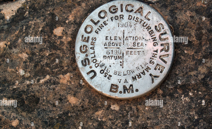
A benchmark is a precisely determined and marked physical point on the ground or a structure that has a known elevation relative to a common datum, usually mean sea level. It serves as a reference point from which elevations of other points in the survey area can be measured.
Characteristics of Benchmarks
- Permanent or Temporary: Benchmarks can be permanent, designed to last for many years (e.g., metal plates, concrete pillars), or temporary, used only for short-term projects.
- Known Elevation: Each benchmark has a precisely determined elevation above a reference level, ensuring consistent vertical control.
- Durability: Permanent benchmarks are made from durable materials like brass, concrete, or steel to resist corrosion and physical damage.
- Stability: Benchmarks are located in stable places unlikely to be disturbed by natural or human activities.
- Visibility: They are marked clearly so surveyors can easily locate them during their work.
- Established by Official Authority: Usually installed and maintained by national or regional surveying agencies or authorized bodies for accuracy and standardization.
Advantages of Benchmarks
- Accuracy: Provide a reliable and highly accurate reference for elevation measurements, crucial for detailed surveying and construction.
- Consistency: Enable consistent vertical control across large areas by serving as universally recognized points of reference.
- Efficiency: Reduce survey time and effort by providing pre-established points for leveling.
- Supporting Infrastructure: Assist in the construction and engineering process, such as road building, drainage, and mapping.
- Repeatability: Allow surveys to be repeated or checked over time against stable, known points.
- Versatility: Useful in various fields, including land management, architecture, civil engineering, and environmental studies
Based on their permanency and precision, benchmarks are classified into four main types:
- G.T.S. Bench Marks (Great Trigonometrical Survey Bench Marks)
- Permanent Bench Marks
- Arbitrary Benchmarks
- Temporary Bench Marks
G.T.S. Bench Marks
The Great Trigonometrical Survey (G.T.S.) Benchmarks are the most accurate and permanent type of benchmarks established by the Survey of India. These benchmarks serve as critical reference points for elevation, precisely determined relative to the mean sea level (MSL).
Their elevations are calculated based on tide observations at Mumbai port taken over a long period of 19 years, which includes various tidal cycles, such as the 18.6-year lunar nodal cycle, ensuring high accuracy.
These G.T.S. Bench Marks are spaced approximately every 100 kilometers across the country and form the primary vertical control network for large-scale geodetic surveys and infrastructure projects.
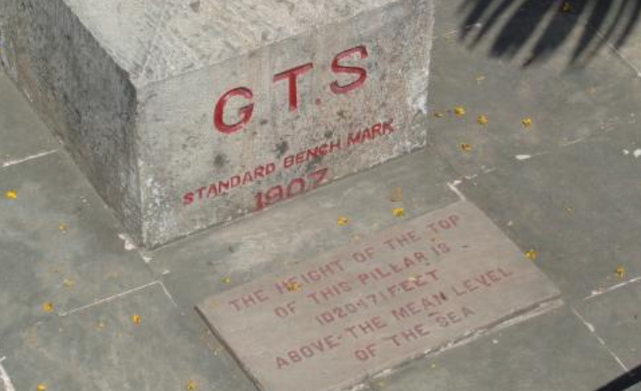
The elevation data of G.T.S. Bench Marks is published in leveling pamphlets and shown on topographical maps, providing essential vertical references for engineering projects like canal construction, railways, highways, and other large regional developments. Due to their high precision and permanence, G.T.S. Bench Marks are foundational for establishing consistent vertical control across wide geographic areas.
Additional important information about G.T.S. Bench Marks
- G.T.S. benchmarks form the primary vertical control network for the entire country
- They are typically marked with permanent monuments or plaques for easy identification
- Regular maintenance and verification of these benchmarks ensure long-term reliability
- The 19-year observation period accounts for various tidal cycles, including the 18.6-year lunar nodal cycle, providing a highly accurate mean sea level reference
- G.T.S. benchmarks are crucial for large-scale engineering projects, such as canal systems, railways, and highways, that span multiple regions
- G.T.S. benchmarks within 1° Latitude and 1° Longitude areas are documented in leveling pamphlets
Permanent Bench Marks
Trigonometrical Survey (G.T.S.) Bench Marks by various government agencies, such as the Survey of India and the Public Works Department (PWD). These benchmarks are set on clearly defined and enduring natural or man-made features to ensure long-term availability.
Examples of locations where permanent benchmarks are established include isolated rock formations, culverts, kilometer stones, railway platforms, and gate pillars of inspection houses.
Permanent Bench Marks created by the Survey of India are engraved with inscriptions like “G.T.S.O B.M.,” indicating their origin and type. Their elevations are documented in leveling pamphlets, making them accessible for surveyors and engineers in need of reference data. Bench marks established by the P.W.D. are marked differently, typically on flat surfaces by etching a rectangle, below or above which the letters “B.M” (Bench Mark) and the Reduced Level (R.L.) of the mark are inscribed. The rectangle is often filled in Japan black to make the marking stand out.
The primary purpose of permanent benchmarks is to serve as intermediate reference points between the highly precise G.T.S. Bench Marks, providing critical vertical control for engineering projects such as irrigation, roadworks, and construction, where maintaining precise elevation levels is essential for functionality and safety.
Additional Important Information about Permanent Benchmarks
- Permanent Bench Marks bridge the gap between widely spaced G.T.S. Bench Marks, allowing for more precise local measurements
- They play a vital role in urban development, road construction, and local flood control projects
- The use of durable materials and protected locations helps ensure the longevity of these benchmarks
- In modern practice, many Permanent benchmarks are now being integrated with GPS coordinates for enhanced precision and ease of location
Arbitrary Benchmarks
Arbitrary Benchmarks (ABM) are reference points used in surveying for smaller, localized leveling tasks where high precision is not necessary.
The Great Trigonometrical Survey (G.T.S.) or Permanent Bench Marks, and Arbitrary Bench Marks have an elevation that is assumed arbitrarily for the convenience of a particular project. They are not connected to any official vertical datum such as mean sea level.
These benchmarks are often assigned a convenient elevation at the start of a project, such as zero or 100 meters. They are used for temporary or minor construction and surveying tasks where long-term or absolute accuracy is not critical.
For example, the elevation of a stone, building corner, or any stable point may be designated as an arbitrary benchmark.
Characteristics of Arbitrary Benchmarks:
- The elevation is assumed arbitrarily and is not tied to national or regional benchmarks.
- They are used for small-scale or short-term projects where formal benchmarks are unavailable or unnecessary.
- Not suitable for projects requiring high accuracy or long-term vertical control.
- Typically abandoned after project completion, as they have no official significance outside their immediate use.
- Care must be taken to document their assumed elevation clearly to avoid confusion.
- If needed later, the arbitrary elevations can be converted to an official datum by connecting to a known benchmark and applying a conversion factor.
Additional Important Information about Arbitrary Benchmarks
- When using Arbitrary benchmarks, it’s crucial to clearly document their arbitrary nature in all project records
- If the project later needs to be tied into an official datum, a conversion factor can be established by connecting to a known benchmark. (This factor is the difference between the arbitrary elevation assigned to a point and its true elevation as determined by connecting to an official benchmark. For example, if an Arbitrary Benchmark was assigned an elevation of 100.00 m but its true elevation is found to be 543.27 m, the conversion factor of 443.27 m would be added to all project elevations to align them with the official datum.)
- Care should be taken to avoid confusion between Arbitrary benchmarks and official benchmarks in the same area
- For projects that may expand in the future, it’s often wise to relate Arbitrary Bench Marks to a nearby official benchmark, even if not immediately necessary.
Best Practices While Using Arbitrary Benchmarks
- Clearly mark Arbitrary Bench Marks as such to prevent future misunderstandings
- Document the assumed elevation and any relevant local references
- Consider the potential future needs of the project when deciding whether to use Arbitrary Benchmarks
- When possible, establish a relationship with at least one official benchmark for potential future use
Temporary Bench Marks
Temporary Bench Marks (TBMs) are temporary reference points with known elevations used during surveying and construction works when permanent benchmarks are unavailable or inaccessible.
TBMs mark the endpoint of a day’s surveying work and provide a starting point for continuation the next day, ensuring consistency across different phases of the project.
TBMs are placed on stable and easily identifiable features like parapet walls, kilometer stones, verandah floors, or tree roots to avoid disturbance. They are often marked using sturdy and visible means such as stakes, metal pins, painted marks, or temporary monuments.
To maintain accuracy and avoid confusion, the exact location and description of the TBM must be documented meticulously in level books, including details like the feature it is placed on and the corresponding Reduced Level. These descriptions are essential for resuming work accurately, ensuring consistency in elevation measurements across different days.
Characteristics of Temporary Benchmarks:
- Intended for short-term use, often just for the duration of a specific surveying or construction task.
- Placed on stable, well-defined, and easily identifiable physical features such as kilometer stones, parapet walls, the floor of verandahs, or the roots of old trees to minimize disturbance.
- The elevation of a TBM is called its Reduced Level (R.L.), which allows continuity in accurate leveling from one day to the next.
- Locations and detailed descriptions of TBMs are meticulously recorded in level books, including details of the physical feature used for placement and the corresponding Reduced Level, ensuring consistency and accuracy.
- In areas prone to disturbances or vandalism, multiple TBMs may be established to mitigate risk.
- TBMs should be periodically checked against permanent benchmarks in long-term projects to maintain accuracy.
- Durable markers or paint are often used to identify TBMs clearly, and photographs of the location and surroundings are taken to aid relocation.
- Using natural features that are unlikely to be disturbed is preferred for establishing TBMs.
- TBMs are crucial in linear projects where multiple are established at regular intervals to reduce cumulative errors.
- Communication about TBMs among all team members is vital to prevent accidental disturbance.
Additional Important Information about Temporary Benchmarks
- When selecting a TBM, consider potential disturbances or changes that might occur overnight
- In areas prone to vandalism or accidental disturbance, it’s advisable to establish multiple TBMs
- For projects spanning weeks or months, it’s crucial to periodically check TBMs against known permanent bench marks to ensure accuracy
- In some cases, well-established TBMs may be upgraded to semi-permanent status for longer projects
Best Practices While Using Temporary Benchmarks
- Use durable markers or paint to clearly identify the exact point of the TBM
- Take photographs of the TBM and its surroundings for easy relocation
- When possible, use natural features unlikely to be disturbed by human activity
- Establish TBMs at regular intervals in linear projects to minimize cumulative errors
- Inform all team members about the location and importance of TBMs to prevent accidental disturbance